
Navigation:
- The process or activity of accurately ascertaining one’s position and planning and following a route
- The passage of ships
‘The demanding test of landfall’ (David Lewis, We The Navigators)
Once upon a time, in the old days, those imagined times when everything was better – yet somehow much harder – when everybody knew their place (save for heroes and plucky gals), men were men and women were - well, women were something else.
Not in those old days but in the real ones, navigation, setting your course, relied on knowing where you were not.
Much celestial reckoning relies on the circle of uncertainty: your position lines have met and somewhere in there, you are. Assuming you read the sextant right, the chronometer was accurate, the sums worked out, you were in the area you had drawn on the chart. Assuming you had a chart.

Even today not everywhere is known. Europa found an uncharted shoal, a shallow area, in the Bransfield Strait. A new hazard perhaps, not so shallow as to risk a grounding but a place the water could pile up, an Antarctic popple to grab at the unwary. Yet we assume there are maps, places drawn and positions fixed. Here we say, and here. And honestly woman, turn it the other way up if you don’t know your left from your right.
Afloat, the boat’s direction is not always yours. Looking aft the rocks may be to your right, but they will be to port of your ship. Danger away, over there. Your circle of uncertainty needs also to be safe. Know you are not where danger is.
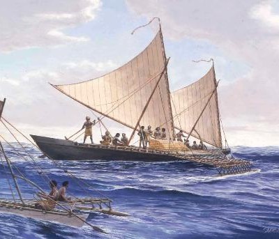
In two millennia exploring the Pacific, the Polynesians became wise in the ways that water touches land. Not bemused by compasses or misled by charts, they found their way by swell and smell, fingering their stick maps incomprehensible to western eyes hypnotised by the necessities of north. They recited the path, the ara fetū course set by the guiding stars of the horizon which, rising one by one, show the way at night as they ventured into the unknown in waka of surpassing seaworthiness.

They travelled into waters no-one had ever seen, unheralded by Juno or Rover, maybe following the shearwater and the long-tailed cuckoo. Maui and Kope rode the tradewinds and ocean currents into the unknown, pulling their canoes towards the high mountains that emerged from the sea, the volcanic smoke dispersing with the whale’s gasp.
The Polynesians left few records. They carried no theodolites nor paper, kept no records and left no charts, unlike the detailed drawings brought home from Endeavour and the other probing Europeans. Before the pakeha laid down their maps and flags, you had to be present to understand the contours of the horizon. If you were not at the masters’ feet to learn the rhythms of the sea, you had no business stepping your mast for the great adventure.
Navigation is not reading a screen nor following the mystery voice with no sense of your surroundings. Navigation is charting the future, it is both memory and exploration.
The art and science of Polynesian navigation in the settlement of the south Pacific is a fascinating subject. This micro-essay refers to two key sources:
We, the Navigators: The Ancient Art of Landfinding in the Pacific by David Lewis
Waka Moana: Voyages of the Ancestors: Edited by K R Howe. The quotation below comes from the essay Voyaging and Settlement by Geoffrey Irwin in that book.
Whatever the reason, widespread human dispersal accompanied by technological innovations has been a species characteristic for a million years and is now still as evident as ever as people over-winter on the ice-caps and probe the fringes of space.

